
Visiting Popocatepetl
Helpful resort information to assist planning your trip to Popocatepetl.
- Season opens—
- Season closes—
- Accommodation—
- Restaurants | Bars— | —
- Nearest Airport Mexico City
- Nearest Train Station —
- Tourist Office Website—
- Tourist Office Phone—
Popocatepetl Features
The terrain at Popocatepetl includes::
- Halfpipes—
- Terrain Parks—
- X-Country—
- Ski Hire—
What's it like at Popocatepetl?
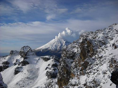
Popocatepetl is a volcano with forested slopes and a snow-capped cone and large crater. It is the second highest peak in Mexico at 17,887 feet (5452 metres) behind Pico de Orizaba at 18,405feet. The name Popocatepetl is Aztec for Smoking Mountain, and is often, conveniently, shortened to Popo. Popo and its neighboring volcano Iztaccihuatl (17,342 feet.) dominate the sky southeast of Mexico City. They are located less than fifty miles from the city, and are separated from each other by a ten mile ridge. Popo's last major eruption was in 1947, although on December 21st 1994, it awakened from dormancy, spewing gas and ash, which was carried by the wind as far as Puebla, 25 miles east. Surrounding towns were evacuated, and scientists have since been closely monitoring Popo for signs of a possible eruption. The first recorded ascent of Popocatepetl was by the Tecuanipas tribe in 1289. The first Spanish ascent of the mountain was an expedition led by Diego de Ordaz in 1519. Emperor Moctezuma sent ten warriors to climb the mountain sometime between 1502 and 1519. Only two of these warriors survived the climb.
Explore Popocatepetl Location Map
Interactive Popocatepetl trail map and piste map. View the piste and trails as well as the surrounding terrain and mountain contours for backcountry action. Find and compare nearby resorts by clicking on the resort markers.

Popocatepetl Live Weather
| Resort | Snow Depth | Temp. (°C) | Wind (km/h) | Weather | ||
|---|---|---|---|---|---|---|
| Top Lift: | 0 | |||||
| Middle Lift: | 10 | |||||
| Bottom Lift: | 19 | |||||
When's the snowiest month to visit Popocatepetl?
What's the snow currently like in Popocatepetl?
A summary of the current snow conditions in Popocatepetl. View more information on the Popocatepetl detailed snow report page.
- Piste Condition—
- Off-piste Condition—

| Upper snow depth: | ||
|---|---|---|
| Lower snow depth: | ||
Visitor Reviews of Popocatepetl
Taylor Ramsay from United States writes:
I cannot seem to find any information on how to ski at Popo or where there might be lifts. I read the most recent comment here from El Pico de Orizaba and felt hopeful, but I cannot find any further information. Does anyone have any more info?
Resorts close to Popocatepetl
Discover ski resorts near Popocatepetl. Click below to view there ski resort guides.
 Ski ApacheLast snow: 2.0 cm Tue 09 Apr
 Lifts: 11
 Pistes: 551732 km away
- Mount Lemmon Ski ValleyLast snow: 2.0 cm Fri 05 AprLifts: 3Pistes: —1923 km away
- Sandia PeakLast snow: 1.0 cm Sat 27 AprLifts: 7Pistes: 251955 km away
- Sunrise Park ResortLast snow: 4.0 cm Sat 27 AprLifts: 10Pistes: 651983 km away
- Ski Santa FeLast snow: 1.0 cm Fri 26 AprLifts: 6Pistes: 671984 km away
 Nearest