
Analysis of the Current Dynamic of the Jalisco Block, Mexico through GNSS Observations †


Faculty of Earth and Space Sciences, Autonomous University of Sinaloa, Culiacan 80040 Sinaloa, Mexico
*
Author to whom correspondence should be addressed.
†
Presented at the IV Conference on Geomatics Engineering, Madrid, Spain, 6–7 July 2023.
Environ. Sci. Proc. 2023, 28(1), 3; https://doi.org/10.3390/environsciproc2023028003
Published: 18 December 2023
(This article belongs to the Proceedings of IV Conference on Geomatics Engineering)
Abstract
:Mexico is surrounded by a highly dynamic tectonic environment, where the area of greatest influence is in the west, since it is where large earthquakes occur and tectonic blocks are generated due to the subduction of two oceanic plates in the North American plate. In the present study, the horizontal velocities of 15 GNSS stations of continuous operation are calculated, over a period of 11 years, which are located within the Jalisco Block, Mexico with the objective of analyzing the current dynamics of this tectonic block, which is mainly influenced by the oblique subduction of the Rivera plate.
1. Introduction
Mexico is one of the countries with the highest tectonic and seismic activity in the world, mainly due to the interaction of five tectonic plates (Pacific, Cocos, Rivera, Caribbean and North America), where most of its territory is located on the North American plate. In the north and southeast region, it borders the Pacific and Caribbean plates (respectively) through transform boundaries [1,2]. The western region of the country presents the highest seismicity, as well as the largest magnitude earthquakes, since it is influenced by the subduction of the Rivera and Cocos plates [3], where, according to [4], earthquakes of a magnitude greater than Mw > 9.0 could occur.
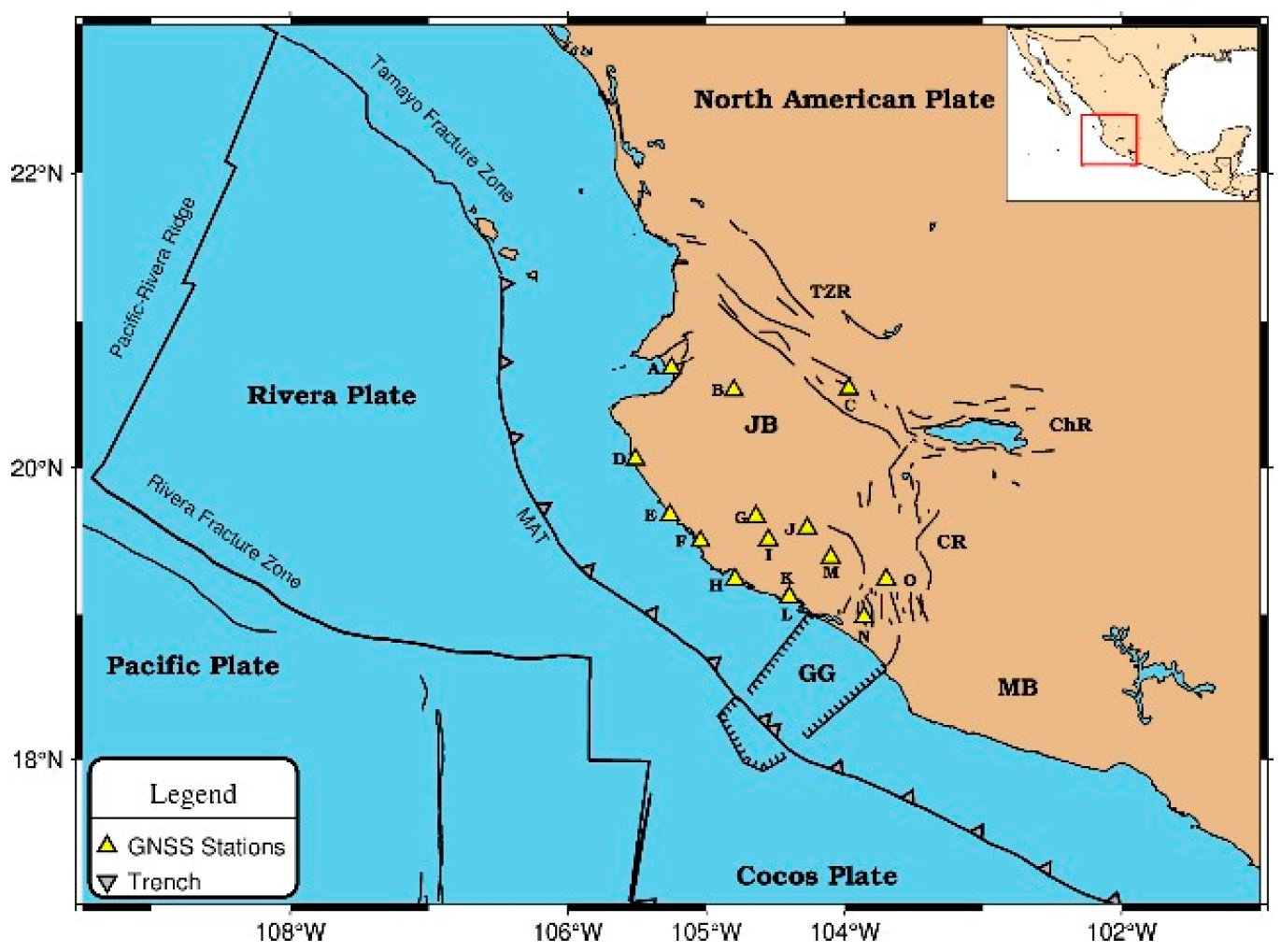
The study area is located in western Mexico (Figure 1), where the existence of a tectonic unit called the Jalisco Block (JB) has been proposed [5]; in addition, it is known as one of the areas with the greatest tectonic and seismic influence in the country [6]. The JB is mainly influenced by the oblique subduction of the Rivera plate in the western part; likewise, it is delimited by two continental deformation zones. To the east is the Colima rift (CR), trending N-S [7], which is a tectonic structure with purely extensional deformation [8] that has been considered by some as researchers as the eastern limit of the JB [9], whereas in the north is the Tepic-Zacoalco (TZR) rift [10], which runs NW-SE [11].
2. Materials and Methods
The GNSS stations used come from different continuously operating geodetic networks such as the TLALOCNet (https://www.unavco.org/projects/past-projects/tlalocnet/tlalocnet.html, accessed on 10 December 2020), the CORS (https://geodesy.noaa.gov/CORS_Map/, accessed on 10 December 2020), and the RGNA (https://www.inegi.org.mx/temas/geodesia_activa/, accessed on 10 December 2020). Quality analysis was carried out on the GPS observations only for a period of 11 years (2010–2020) through the TEQC program [12], which focuses on the multipath effect, observation effectiveness, cycle skip count (CSR), and signal-to-noise ratio (SNR).
Subsequently, the processing of the observations was carried out through the GAMIT/GLOB-K software version 10.71, the software has been developed by MIT, Scripps Institution of Oceanography and Harvard University with support from the National Science Foundation, by T. A. Herring, M. A. Floyd, R. W. King, S. C. McClusky, United States of America [13] in order to obtain the time series that describes the rate of speed and direction of JB stations. For this, various parameters such as precise ephemeris (SP3), orientation parameters of the earth, ocean charge model, among others, were used. Likewise, the North American plate was used as a reference since according to [14], the movements of the GPS sites in Jalisco are better described in relation to this plate than with a global reference frame, since the speeds of the reference site are minimized [15]; thus, the displacements are obtained purely from the phenomenon in question. The Tsview tool, by Thomas Herring, United States of America, complemented the GAMIT/GLOB-K software for GPS time series analysis [16]. It filtered out atypical data and outliers using the 3-sigma criterion [17,18,19]. Corrections were made for hardware/firmware changes and earthquake-induced landslides. The “Real Sigma” algorithm provided precise noise properties and realistic uncertainty estimation.
3. Results and Discussion
The stations used for our study presented effectiveness values greater than 95% in their entirety, likewise, the SNR values turned out to be greater than 30 dBHz for all the stations, which reflects the quality of the signal (according with IGS recommendations (https://igs.org/station-resources/#site-guidelines, accessed on 25 October 2020) and [15]). However, most of the stations present an average multipath value of 0.5 m in MP1 and 0.4 m in MP2 (with values close to those recommended) (Table 1).
The velocity vectors obtained through the analysis carried out in Tsview show preferential directions in a north-northwest direction in most of the stations, which is consistent with the direction and geometry of subduction of the Rivera plate. Likewise, the stations located in the south-southeast zone and in the coastal zone present the highest velocities, with values ranging from 6.29 to 10.81 mm/year, while the stations located to the north-northwest, near the Tepic-Zacoalco rift present values of approximately 3.0 mm/year (Figure 2). On the other hand, in the central zone of the Jalisco Block, a decrease in velocity was observed at station G, which could be related to a blockage of the Rivera plate at the subduction interface proposed by Cosenza-Muralles et al. [20] in this zone.
The velocities obtained in our study suggest a counterclockwise rotation of the JB, with a preferential direction towards north-northwest in most stations, which agrees with the subduction direction estimated by the Rivera plate movement model proposed by DeMets et al. [21]. The above shows the influence of the movement of the Rivera plate on the movement of the Jalisco Block.
Considering the information presented above, the ground velocity shortening observed near station G could be related to the blocking zone observed at the subduction interface in this same region [20], which would indicate that it is observing a deformation within the JB due to the coupling between the Rivera plates and said block.
4. Conclusions
The velocity gradient observed in the JB reveals the influence of the oblique subduction of the Rivera plate, as well as its influence on the generation of earthquakes in this area. On the other hand, the decrease in velocity observed in the central zone is associated with the possible accumulation of tension with the potential to generate an earthquake greater than Mw > 7.0. Future studies intend to estimate the b-value in the JB area using freely accessible seismic catalogs to verify if tension is actually being generated in this area and correlate it with the results.
Author Contributions
Conceptualization, methodology, software, validation, formal analysis, investigation, data curation, writing—original draft preparation, supervision and project administration, J.L.C.Z.; validation, writing—review and editing, visualization and supervision, J.L.C.Z., M.E.T.S. and X.G.T.C. All authors have read and agreed to the published version of the manuscript.
Funding
This research was funded by the National Council of Science and Technology (CONACyT) in Mexico, grant number 817394.
Institutional Review Board Statement
Not applicable.
Informed Consent Statement
Not applicable.
Data Availability Statement
The data can be obtained from the corresponding author on request.
Acknowledgments
The authors would like to thank International GNSS Services (IGS), UNAVCO, National Oceanic and Atmospheric Administration (NOAA), and INEGI (National Institute of Statistics and Geography) for freely providing high-quality data for the analysis. The seismological data were obtained by the National Seismological Service in Mexico. We are grateful to the SSN staff for station maintenance, acquisition, and distribution of data.
Conflicts of Interest
The authors declare no conflict of interest.
References
- Ortega, R.; Quintanar, L.; Rivera, L. Full Moment Tensor Variations and Isotropic Characteristics of Earthquakes in the Gulf of California Transform Fault System. Pure Appl. Geophys. 2013, 171, 2805–2817. [Google Scholar] [CrossRef]
- Alonso-Henar, J.; Álvarez-Gómez, J.A.; Martínez-Díaz, J.J. Neogene-quaternary evolution from transpressional to transtensional tectonics in Northern Central America controlled by cocos: Caribbean subduction coupling change. J. Iber. Geol. 2017, 43, 519–538. [Google Scholar] [CrossRef]
- Bernal-López, L.A.; Garibaldi, B.R.; León Soto, G.; Valenzuela, R.W.; Escudero, C.R. Seismic Anisotropy and Mantle Flow Driven by the Cocos Slab Under Southern Mexico. Pure Appl. Geophys. 2016, 173, 3373–3393. [Google Scholar] [CrossRef]
- Muldashev, I.A.; Sobolev, S.V. What Controls Maximum Magnitudes of Giant Subduction Earthquakes? Geochem. Geophys. Geosystems 2020, 21, e2020GC009145. [Google Scholar] [CrossRef]
- Camacho, M.; Alvarez, R. Gravimetric analysis of the rifts and volcanic fields of the Jalisco block, Mexico. Tectonophysics 2020, 791, 228577. [Google Scholar] [CrossRef]
- Núñez-Cornú, F.J.; Sandoval, J.M.; Alarcón, E.; Gómez, A.; Suárez-Plascencia, C.; Núñez, D.; Trejo-Gómez, E.; Mariscal, O.S.; Ortiz, J.G.C.; Zúñiga-Medina, L.M. The Jalisco Seismic Accelerometric Telemetric Network (RESAJ). Seism. Res. Lett. 2018, 89, 363–372. [Google Scholar] [CrossRef]
- Pacheco, J.F.; Mortera-Gutiérrez, C.A.; Delgado, H.; Singh, S.K.; Valenzuela, R.W.; Shapiro, N.M.; Santoyo, M.A.; Hurtado, A.; Barrón, R.; Gutiérrez-Moguel, E. Tectonic significance of an earthquake sequence in the Zacoalco half-graben, Jalisco, Mexico. J. S. Am. Earth Sci. 1999, 12, 557–565. [Google Scholar] [CrossRef]
- Rosas-Elguera, J.; Ferrari, L.; Garduño-Monroy, V.H.; Urrutia-Fucugauchi, J. Continental boundaries of the Jalisco block and their influence in the Pliocene-Quaternary kinematics of western Mexico. Geology 1996, 24, 921–924. [Google Scholar] [CrossRef]
- Serrato-Díaz, G.S.; Bandy, W.L.; Gutiérrez, C.A.M. Active rifting and crustal thinning along the Rivera-Cocos plate boundary as inferred from Mantle Bouguer gravity anomalies. Geofis. Int. 2004, 43, 361–381. [Google Scholar] [CrossRef]
- Núñez-Cornú, F.J. Peligro Sísmico en el Bloque de Jalisco, México. Física Tierra 2011, 23, 199–229. [Google Scholar] [CrossRef]
- Ownby, S.E.; Lange, R.A.; Hall, C.M. The eruptive history of the Mascota volcanic field, western Mexico: Age and volume constraints on the origin of andesite among a diverse suite of lamprophyric and calc-alkaline lavas. J. Volcanol. Geotherm. Res. 2008, 177, 1077–1091. [Google Scholar] [CrossRef]
- Estey, L.H.; Meertens, C.M. TEQC: The Multi-Purpose Toolkit for GPS/GLONASS Data. GPS Solut. 1999, 3, 42–49. [Google Scholar] [CrossRef]
- Herring, T.A.; King, R.W.; Floyd, M.A.; Mcclusky, S.C. Introduction to GAMIT/GLOBK. 2018. Available online: http://geoweb.mit.edu/gg/Intro_GG.pdf (accessed on 15 May 2020).
- Hutton, W.; DeMets, C.; Sánchez, O.; Suárez, G.; Stock, J. Slip kinematics and dynamics during and after the 1995 October 9 Mw = 8.0 Colima-Jalisco earthquake, Mexico, from GPS geodetic constraints. Geophys. J. Int. 2001, 146, 637–658. [Google Scholar] [CrossRef]
- Xiao, Y.; Yao, M.H.; Tang, S.H.; Liu, H.F.; Xing, P.W.; Zhang, Y. Data quality check and visual analysis of cors station based on anubis software. Int. Arch. Photogramm. Remote Sens. Spat. Inf. Sci. 2020, 42, 1295–1300. [Google Scholar] [CrossRef]
- Herring, T. MATLAB Tools for viewing GPS velocities and time series. GPS Solut. 2003, 7, 194–199. [Google Scholar] [CrossRef]
- Bogusz, J. Annual signals observed in regional GPS networks. Acta Geodyn. Geomater. 2014, 11, 125–131. [Google Scholar] [CrossRef]
- Kall, T.; Oja, T.; Kollo, K.; Liibusk, A. The Noise Properties and Velocities from a Time-Series of Estonian Permanent GNSS Stations. Geosciences 2019, 9, 233. [Google Scholar] [CrossRef]
- Maciuk, K.; Vārna, I.; Xu, C. Characteristics of seasonal variations and noises of the daily double-difference and PPP solutions. J. Appl. Geod. 2020, 15, 61–73. [Google Scholar] [CrossRef]
- Cosenza-Muralles, B.; DeMets, C.; Márquez-Azúa, B.; Sánchez, O.; Stock, J.; Cabral-Cano, E.; McCaffrey, R. GPS-derived interseismic fault locking along the Jalisco–Colima segment of the Mexico subduction zone. Geophys. J. Int. 2021, 228, 2174–2197. [Google Scholar] [CrossRef]
- DeMets, C.; Gordon, R.G.; Argus, D.F. Geologically current plate motions. Geophys. J. Int. 2010, 181, 1–80. [Google Scholar] [CrossRef]
Figure 1.
Study area map with yellow triangles representing GNSS stations. JB: Jalisco Block. MB: Michoacan Block. GG: El Gordo Graben. CR: Colima Rift. TZR: Tepic-Zacoalco Rift. ChR: Chapala Rift.
Figure 1.
Study area map with yellow triangles representing GNSS stations. JB: Jalisco Block. MB: Michoacan Block. GG: El Gordo Graben. CR: Colima Rift. TZR: Tepic-Zacoalco Rift. ChR: Chapala Rift.

Figure 2.
Velocity map. Blue arrows: Velocities of GNSS stations. Magenta: Velocities of Rivera and Cocos plate.
Figure 2.
Velocity map. Blue arrows: Velocities of GNSS stations. Magenta: Velocities of Rivera and Cocos plate.


Table 1.
Quality analysis of GPS observations.
| Station | Effectiveness | MP1 | MP2 | SNR1 | SNR2 | CSR |
|---|---|---|---|---|---|---|
| % | (m) | (m) | (dBHz) | (dBHz) | (1000/(o/slps)) | |
| A | 98.1 | 0.9 | 0.9 | 46.6 | 42.5 | 0.1 |
| B | 98.5 | 0.5 | 0.4 | 45.2 | 33.3 | 0.8 |
| C | 99.7 | 0.4 | 0.3 | 45 | 33.6 | 0.1 |
| D | 98.9 | 0.7 | 0.5 | 44.7 | 30.7 | 0.5 |
| E | 99.6 | 0.4 | 0.3 | 44.5 | 30 | 0.1 |
| F | 99.7 | 0.4 | 0.3 | 45.1 | 33.4 | 0.2 |
| G | 99.1 | 0.5 | 0.4 | 44.0 | 30.0 | 0.6 |
| H | 99.4 | 0.5 | 0.3 | 44.0 | 30.0 | 0.1 |
| I | 99.4 | 0.4 | 0.3 | 44.7 | 33.3 | 0.2 |
| J | 77.7 | 0.9 | 0.5 | 44.7 | 34.3 | 3.3 |
| K | 99.5 | 0.4 | 0.3 | 44.7 | 30.7 | 0.5 |
| L | 99.5 | 0.4 | 0.3 | 44.7 | 30.7 | 0.5 |
| M | 90.4 | 0.6 | 0.7 | 44.4 | 30.4 | 4.9 |
| N | 97.8 | 0.6 | 0.4 | 44.4 | 30.7 | 0.6 |
| O | 99.2 | 0.1 | 0.3 | 39.2 | 41.7 | 4.5 |
Disclaimer/Publisher’s Note: The statements, opinions and data contained in all publications are solely those of the individual author(s) and contributor(s) and not of MDPI and/or the editor(s). MDPI and/or the editor(s) disclaim responsibility for any injury to people or property resulting from any ideas, methods, instructions or products referred to in the content. |
© 2023 by the authors. Licensee MDPI, Basel, Switzerland. This article is an open access article distributed under the terms and conditions of the Creative Commons Attribution (CC BY) license (https://creativecommons.org/licenses/by/4.0/).
Share and Cite
MDPI and ACS Style
Zavala, J.L.C.; Trejo Soto, M.E.; Torres Carrillo, X.G. Analysis of the Current Dynamic of the Jalisco Block, Mexico through GNSS Observations. Environ. Sci. Proc. 2023, 28, 3. https://doi.org/10.3390/environsciproc2023028003
AMA Style
Zavala JLC, Trejo Soto ME, Torres Carrillo XG. Analysis of the Current Dynamic of the Jalisco Block, Mexico through GNSS Observations. Environmental Sciences Proceedings. 2023; 28(1):3. https://doi.org/10.3390/environsciproc2023028003
Chicago/Turabian StyleZavala, Juan L. Cabanillas, Manuel E. Trejo Soto, and Xóchitl G. Torres Carrillo. 2023. "Analysis of the Current Dynamic of the Jalisco Block, Mexico through GNSS Observations" Environmental Sciences Proceedings 28, no. 1: 3. https://doi.org/10.3390/environsciproc2023028003