
Site Response Evaluation in the Trans-Mexican Volcanic Belt Based on HVSR from Ambient Noise and Regional Seismicity

 ,
,
Abstract
:Featured Application
Abstract
1. Introduction
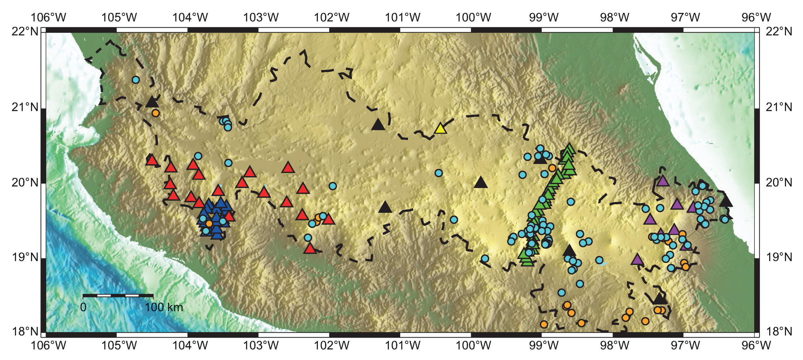
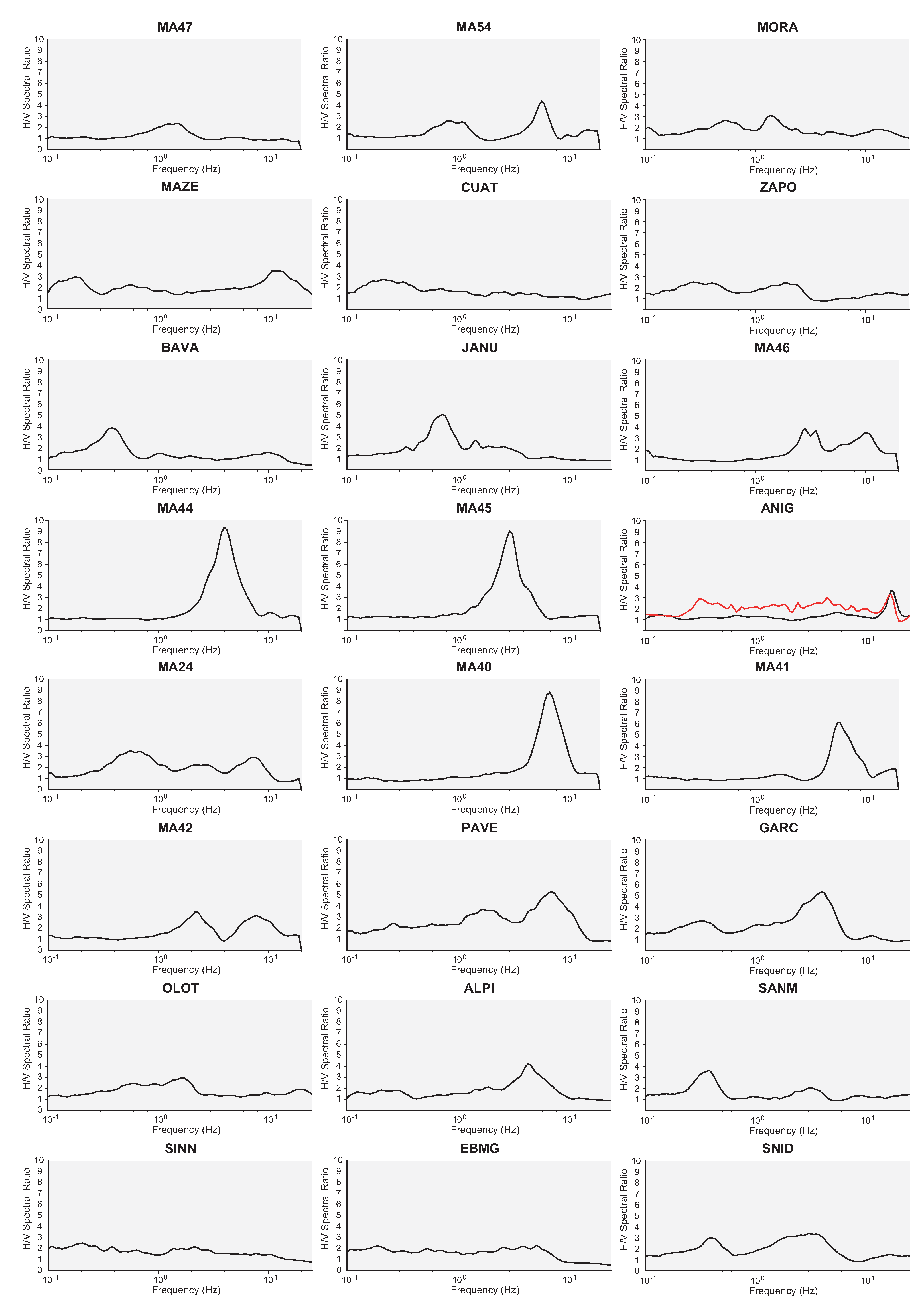
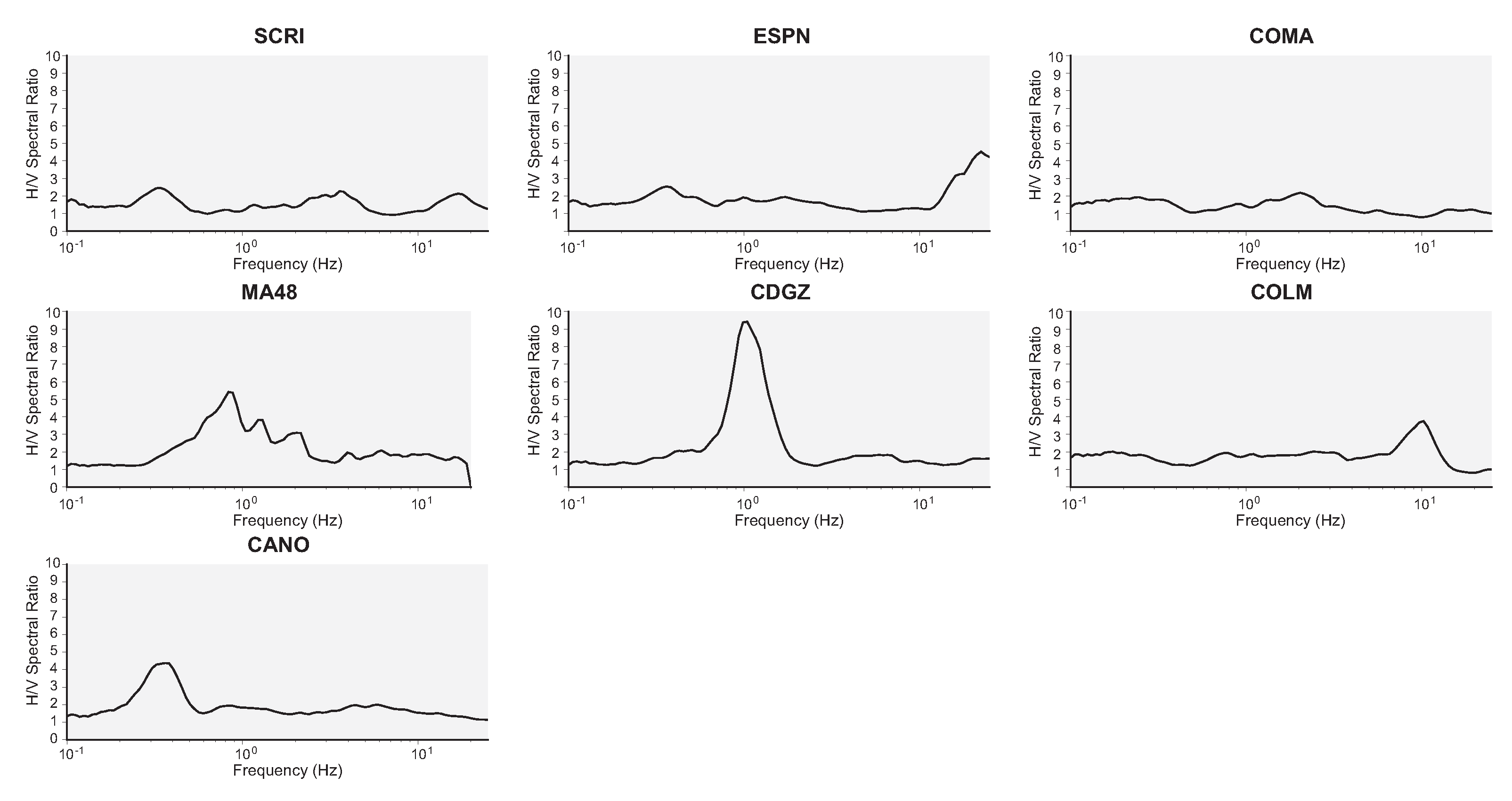
2. Data and Methods
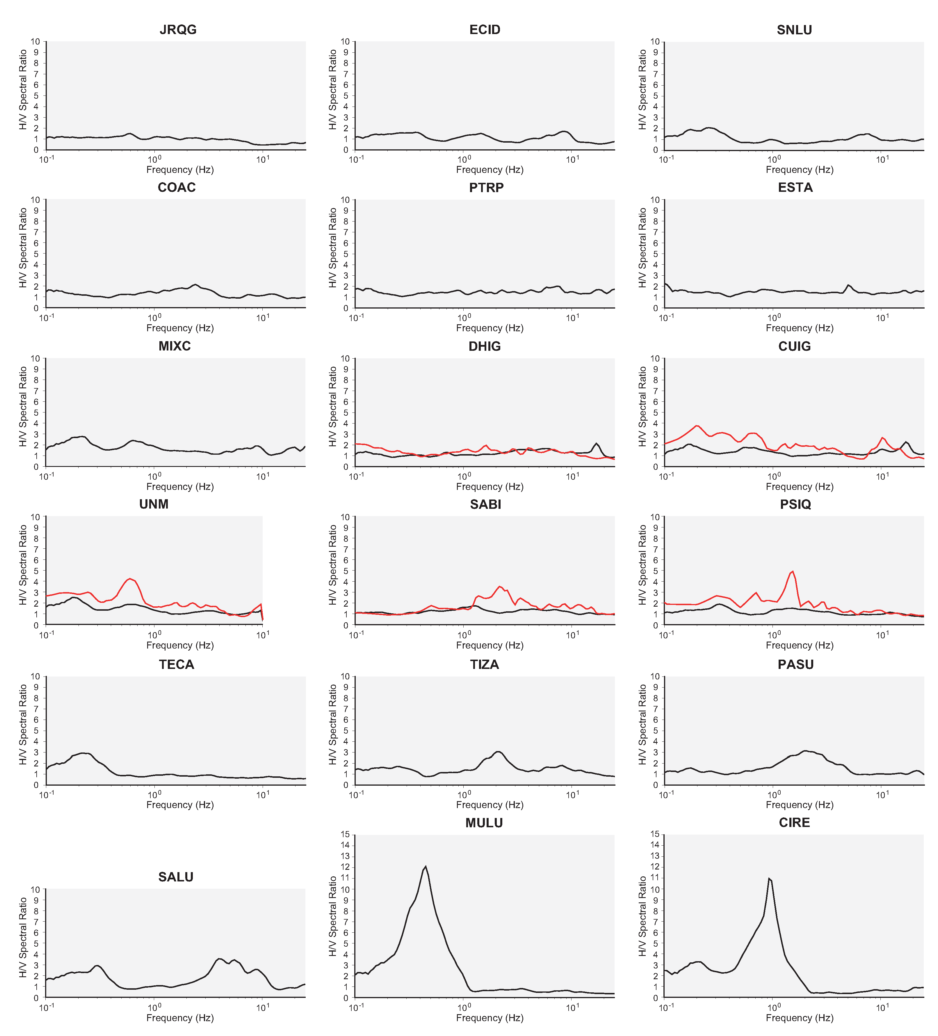
3. Results
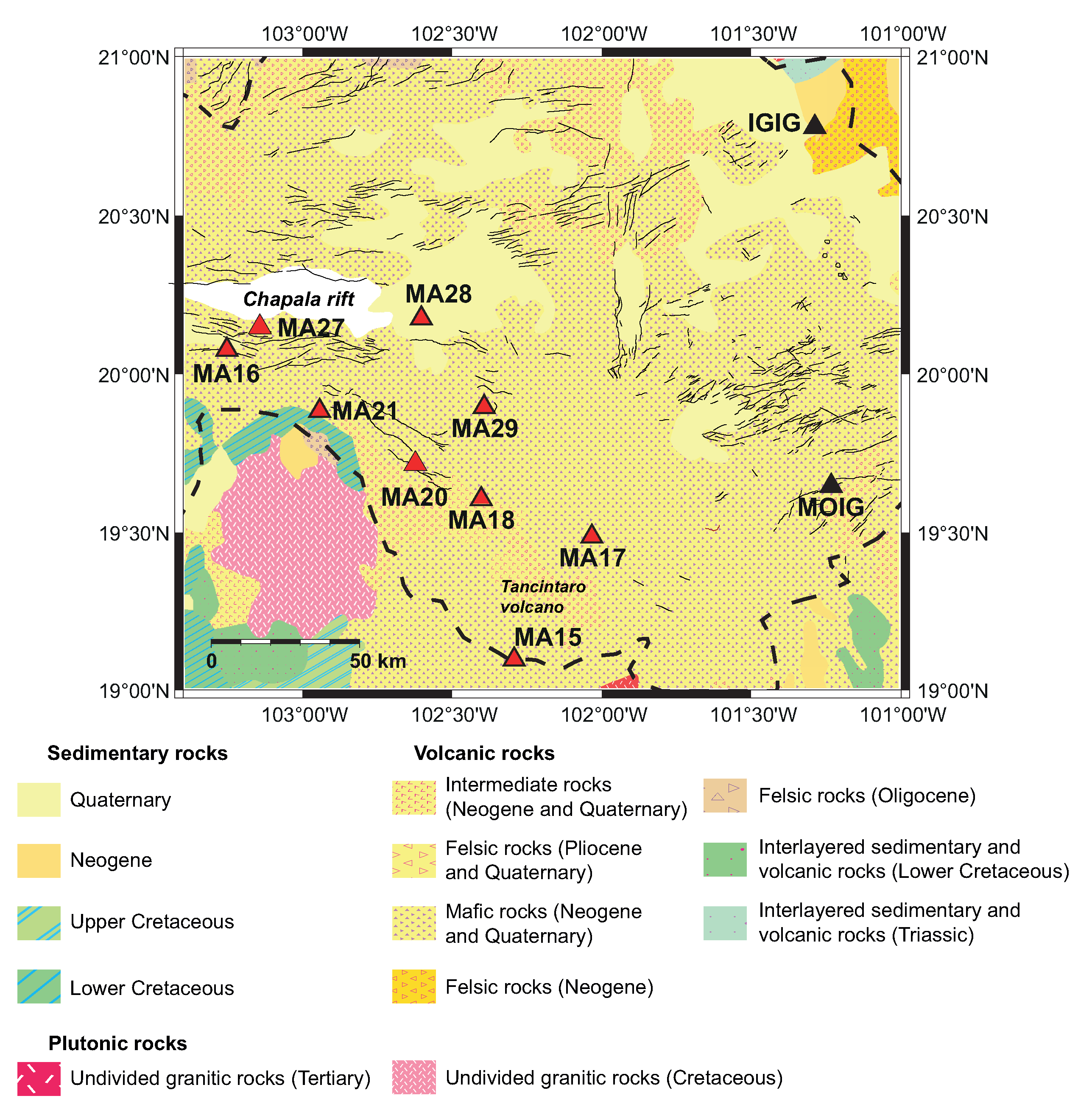
3.1. Western TMVB
3.2. Central TMVB
3.3. Central-Eastern TMVB
3.4. Eastern TMVB
4. Conclusions
Author Contributions
Funding
Institutional Review Board Statement
Informed Consent Statement
Acknowledgments
Conflicts of Interest
References
- Borcherdt, R.D. Effects of local geology on ground motion near San Francisco bay. Bull. Seismol. Soc. Am. 1970, 60, 29–61. [Google Scholar]
- Nakamura, Y. A method for dynamic characteristics estimation of subsurface using microtremor on the ground surface. Railw. Tech. Res. Inst. Q. Rep. 1989, 30, 25–33. [Google Scholar]
- Perron, V.; Gélis, C.; Froment, B.; Hollender, F.; Bard, P.Y.; Cultrera, G.; Cushing, E.M. Can broad-band earthquake site responses be predicted by the ambient noise spectral ratio? Insight from observations at two sedimentary basins. Geophys. J. Int. 2018, 215, 1442–1454. [Google Scholar] [CrossRef]
- Gosar, A. Study on the applicability of the microtremor HVSR method to support seismic microzonation in the town of Idrija (W Slovenia). Nat. Hazards Earth Syst. Sci. 2017, 17, 925–937. [Google Scholar] [CrossRef] [Green Version]
- Madiai, C.; Facciorusso, J.; Gargini, E. Numerical Modeling of Seismic Site Effects in a Shallow Alluvial Basin of the Northern Apennines (Italy). Bull. Seismol. Soc. Am. 2017, 107, 2094–2105. [Google Scholar] [CrossRef]
- Stanko, D.; Gülerce, Z.; Markušić, S.; Šalić, R. Evaluation of the site amplification factors estimated by equivalent linear site response analysis using time series and random vibration theory based approaches. Soil Dyn. Earthq. Eng. 2019, 117, 16–29. [Google Scholar] [CrossRef]
- Sun, Q.; Guo, X.; Dias, D. Evaluation of the seismic site response in randomized velocity profiles using a statistical model with Monte Carlo simulations. Comput. Geotech. 2020, 120, 103442. [Google Scholar] [CrossRef]
- Falcone, G.; Romagnoli, G.; Naso, G.; Mori, F.; Peronace, E.; Moscatelli, M. Effect of bedrock stiffness and thickness on numerical simulation of seismic site response. Italian case studies. Soil Dyn. Earthq. Eng. 2020, 139, 106361. [Google Scholar] [CrossRef]
- Singh, S.K.; Quintanar-Robles, L.; Arroyo, D.; Cruz-Atienza, V.C.; Espíndola, V.H.; Bello-Segura, D.I.; Ordaz, M. Lessons from a Small Local Earthquake (Mw 3.2) That Produced the Highest Acceleration Ever Recorded in Mexico City. Seismol. Res. Lett. 2020, 91, 3391–3406. [Google Scholar] [CrossRef]
- Ferrari, L.; Orozco-Esquivel, T.; Vlad, C.; Marina, M. The dynamic history of the Trans-Mexican Volcanic Belt and the Mexico subduction zone. Tectonophysics 2012, 522–523, 122–149. [Google Scholar] [CrossRef]
- Suárez, G.; Caballero-Jiménez, G.V.; Novelo-Casanova, D.A. Active Crustal Deformation in the Trans-Mexican Volcanic Belt as Evidenced by Historical Earthquakes During the Last 450 Years. Tectonics 2019, 38, 3544–3562. [Google Scholar] [CrossRef]
- Suárez, G.; Ruiz-Barón, D.; Chico-Hernández, C.; Zúñiga, F.R. Catalog of Preinstrumental Earthquakes in Central Mexico: Epicentral and Magnitude Estimations Based on Macroseismic Data. Bull. Seismol. Soc. Am. 2020, 110, 3021–3036. [Google Scholar] [CrossRef]
- Suter, M.; Carrillo-Martínez, M.; Quintero, O. Macroseismic Study of Shallow Earthquakes in the Central and Eastern Parts of the Trans-Mexican Volcanic Belt, Mexico. Bull. Seismol. Soc. Am. 1996, 86, 1952–1963. [Google Scholar]
- Sahakian, V.J.; Melgar, D.; Quintanar, L.; Ramírez-Guzmán, L.; Pérez-Campos, X.; Baltay, A. Ground motions from the 7 and 19 September 2017 Tehuantepec and Puebla-Morelos, Mexico, earthquakes. Bull. Seismol. Soc. Am. 2018, 108, 3300–3312. [Google Scholar] [CrossRef] [Green Version]
- Ordaz, M.; Singh, S.K. Source spectra and spectral attenuation of seismic waves from Mexican earthquakes, and evidence of amplification in the hill zone of Mexico City. Bull. Seismol. Soc. Am. 1992, 82, 24–43. [Google Scholar]
- García, D.; Singh, S.K.; Herráiz, M.; Pacheco, J.F.; Ordaz, M. Inslab earthquakes of Central Mexico: Q, source spectra, and stress drop. Bull. Seismol. Soc. Am. 2004, 94, 789–802. [Google Scholar] [CrossRef]
- Singh, S.K.; Iglesias-Mendoza, A.; García, D.; Pacheco, J.F.; Ordaz, M. Q of Lg waves in the central Mexican Volcanic Belt. Bull. Seismol. Soc. Am. 2007, 97, 1259–1266. [Google Scholar] [CrossRef] [Green Version]
- Lozano, L.; Herráiz, M.; Singh, S.K. Site effect study in central Mexico using H/V and SSR techniques: Independence of seismic site effects on source characteristics. Soil Dyn. Earthq. Eng. 2009, 29, 504–516. [Google Scholar] [CrossRef]
- Clemente-Chávez, A.; Zúñiga, F.R.; Lermo, J.; Figueroa-Soto, A.; Valdés-González, C.; Montiel, M.; Chávez, O.; Arroyo, M. On the behavior of site effects in central Mexico (the Mexican volcanic belt-MVB), based on records of shallow earthquakes that occurred in the zone between 1998 and 2011. Nat. Hazards Earth Syst. Sci. 2014, 14, 1391–1406. [Google Scholar] [CrossRef] [Green Version]
- Zúñiga, F.R.; Lacan, P.; Rodríguez-Pérez, Q.; Márquez-Ramírez, V.H. Temporal and spatial evolution of instrumented seismicity in the Trans-Mexican Volcanic Belt. J. S. Am. Earth Sci. 2020, 98, 102390. [Google Scholar] [CrossRef]
- Ruggieri, S.; Tosto, C.; Rosati, G.; Uva, G.; Ferro, G.A. Seismic Vulnerability Analysis of Masonry Churches in Piemonte after 2003 Valle Scrivia Earthquake: Post-event Screening and Situation 17 Years Later. Int. J. Archit. Herit. 2020, 1–29. [Google Scholar] [CrossRef]
- Godínez-Domínguez, E.A.; Tena-Colunga, A.; Pérez-Rocha, L.E.; Archundia-Aranda, H.I.; Gómez-Bernal, A.; Ruiz-Torres, R.P.; Escamilla-Cruz, J.L. The September 7, 2017 Tehuantepec, Mexico, earthquake: Damage assessment in masonry structures for housing. Int. J. Disaster Risk Reduct. 2021, 56, 1–29. [Google Scholar] [CrossRef]
- Catálogo de Sismos. Available online: http://www2.ssn.unam.mx:8080/catalogo/ (accessed on 16 October 2020).
- Search Earthquake Catalog. Available online: https://earthquake.usgs.gov/earthquakes/search/ (accessed on 16 October 2020).
- ISC Bulletin: Event Catalogue Search. Available online: http://www.isc.ac.uk/iscbulletin/search/catalogue/ (accessed on 16 October 2020).
- GEOSCOPE. French Global Network of Broad Band Seismic Stations; Institut de Physique du Globe de Paris (IPGP) and Ecole Et Observatoire Des Sciences De La Terre De Strasbourg (EOST). [CrossRef]
- Meso America Subduction Experiment. Caltech. Dataset. [CrossRef]
- Pérez-Campos, X. MASE: Undergraduate Research and Outreach as Part of a Large Project. Seismol. Res. Lett. 2008, 92, 232–236. [Google Scholar] [CrossRef] [Green Version]
- West, M. The Colima Deep Seismic Experiment: Imaging the Magmatic Root of Colima Volcano. Int. Fed. Digit. Seismogr. Netw. 2006. [Google Scholar]
- Yang, T.; Grand, S.P.; Wilson, D.; Guzman-Speziale, M.; Gomez-Gonzalez, J.M.; Dominguez-Reyes, T. Seismic structure beneath the Rivera subduction zone from finite-frequency seismic tomography. J. Geophys. Res. Solid Earth 2009, 114, B01302. [Google Scholar] [CrossRef]
- Rodríguez-Domínguez, M.; Pérez-Campos, X.; Montealegre-Cázares, C.; Clayton, R.W.; Cabral-Cano, E. Crustal structure variations in south-central Mexico from receiver functions. Geophys. J. Int. 2019, 219, 2174–2186. [Google Scholar] [CrossRef] [Green Version]
- Wathelet, M.; Chatelain, J.L.; Cornou, C.; Giulio, G.D.; Guillier, B.; Ohrnberger, M.; Savvaidis, A. Geopsy: A user-friendly open-source tool set for ambient vibration processing. Seismol. Res. Lett. 2020, 91, 1878–1889. [Google Scholar] [CrossRef]
- Konno, K.; Ohmachi, T. Ground-motion characteristics estimated from spectral ratio between horizontal and vertical components of microtremor. Bull. Seismol. Soc. Am. 1998, 88, 228–241. [Google Scholar]
- SESAME Team. Guidelines for the Implementation of the H/V Spectral Ratio Technique on Ambient Vibrations: Measurements, Processing and Interpretation; SESAME European Research Project. 2004. Available online: http://sesame.geopsy.org/Papers/HV_User_Guidelines.pdf (accessed on 15 August 2020).
- Reed, J.C.; Wheeler, J.O.; Tucholke, B.E. Decade of North American Geology Geologic Map of North America—Perspectives and Explanation; The Geological Society of America: Boulder, CO, USA, 2015. [Google Scholar]
- Suter, M. The A.D. 1567 Mw 7.2 Ameca, Jalisco, Earthquake (Western Trans-Mexican Volcanic Belt): Surface Rupture Parameters, Seismogeological Effects, and Macroseismic Intensities from Historical Source. Bull. Seismol. Soc. Am. 2015, 105, 646–656. [Google Scholar] [CrossRef]
- Suter, M. The 1563 MI 8 Puerto de la Navidad Subduction-Zone and 1567 Mw 7.2 Ameca Crustal Earthquakes (Western Mexico): New Insights from Sixteenth-Century Sources. Seismol. Res. Lett. 2019, 90, 366–375. [Google Scholar] [CrossRef]
- Suter, M. The 2 October 1847 MI 5.7 Chapala Graben Triggered Earthquake (Trans-Mexican Volcanic Belt, West-Central Mexico): Macroseismic Observations and Hazard Implications. Seismol. Res. Lett. 2017, 89, 35–46. [Google Scholar] [CrossRef]
- Lacan, P.; Aguirre-Díaz, G.; Audin, L.; Perea, H.; Baize, S.; Zúñiga, F.R.; Ortuño, M. Sedimentary evidence of historical and prehistorical earthquakes along the Venta de Bravo Fault System, Acambay Graben (Central Mexico). Sediment. Geol. 2018, 365, 62–77. [Google Scholar] [CrossRef]
- Rodríguez-Pérez, Q.; Zúñiga, F.R. Seismicity characterization of the Maravatío-Acambay and Actopan regions, central Mexico. J. S. Am. Earth Sci. 2017, 76, 264–275. [Google Scholar] [CrossRef]
- Suárez, G.; Novelo-Casanova, D.A. A Pioneering Aftershock Study of the Destructive 4 January 1920 Jalapa, Mexico, Earthquake. Seismol. Res. Lett. 2018, 89, 1894–1899. [Google Scholar] [CrossRef]


| Network | Period |
|---|---|
| SSN | 2002–present |
| CGEO | 2003–present |
| GEOSCOPE | 1990–present |
| MASE | 2004–2007 |
| CODEX | 2006–2008 |
| MARS | 2006–2007 |
| GECO | 2013–2018 |
| Date | Origin Time | Magnitude | Depth | Latitude | Longitude |
|---|---|---|---|---|---|
| dd/mm/yyyy | hh:mm:ss | (km) | () | () | |
| 08/03/1993 | 14:37:41 | 3.3 | 11 | 19.25 | −98.93 |
| 02/11/1994 | 15:31:21 | 3.7 | 7 | 19.41 | −98.90 |
| 27/03/1996 | 08:05:15 | 3.4 | 8 | 19.77 | −99.01 |
| 17/04/1996 | 11:19:10 | 3.5 | 10 | 19.21 | −98.94 |
| 06/09/1996 | 06:55:00 | 4.0 | 5 | 19.21 | −98.36 |
| 03/07/1997 | 19:39:32 | 2.8 | 7 | 19.25 | −99.44 |
| 25/12/1997 | 01:29:10 | 4.1 | 11 | 18.97 | −98.59 |
| 15/03/1998 | 02:01:49 | 4.2 | 5 | 19.50 | −100.26 |
| 26/10/1998 | 02:35:10 | 3.0 | 6 | 19.06 | −99.17 |
| 26/10/1998 | 07:50:06 | 3.3 | 4 | 19.06 | −99.20 |
| 31/12/1998 | 06:44:05 | 3.8 | 2 | 18.98 | −98.65 |
| 04/01/1999 | 23:21:59 | 3.5 | 3 | 20.11 | −98.98 |
| 19/05/1999 | 20:23:06 | 3.1 | 5 | 19.19 | −98.96 |
| 22/05/1999 | 06:57:26 | 3.1 | 4 | 19.18 | −98.97 |
| 07/06/1999 | 00:24:14 | 3.3 | 5 | 19.17 | −98.96 |
| 15/06/1999 | 20:42:04 | 7.0 | 63 | 18.13 | −97.54 |
| 20/06/1999 | 10:25:21 | 4.0 | 3 | 19.31 | −98.48 |
| 07/12/1999 | 13:53:49 | 3.4 | 3 | 19.22 | −98.92 |
| 04/03/2000 | 20:55:23 | 4.1 | 4 | 18.84 | −98.57 |
| 12/03/2000 | 03:44:48 | 4.1 | 5 | 20.10 | −99.29 |
| 06/07/2000 | 08:36:24 | 3.3 | 8 | 19.18 | −98.93 |
| 06/07/2000 | 13:15:34 | 3.4 | 5 | 19.19 | −98.96 |
| 21/07/2000 | 06:13:39 | 6.0 | 48 | 18.09 | −98.97 |
| 14/10/2000 | 02:44:48 | 3.1 | 12 | 19.36 | −99.19 |
| 15/10/2000 | 07:50:43 | 2.7 | 5 | 19.39 | −99.11 |
| 01/03/2001 | 16:26:42 | 3.5 | 46 | 18.98 | −99.82 |
| 13/06/2001 | 03:57:43 | 3.2 | 12 | 19.27 | −99.42 |
| 14/09/2001 | 17:13:15 | 2.9 | 14 | 19.31 | −99.30 |
| 15/11/2001 | 22:18:22 | 3.5 | 4 | 19.56 | −99.16 |
| 09/05/2002 | 14:25:43 | 3.7 | 19 | 19.49 | −99.01 |
| 04/02/2003 | 10:59:03 | 4.1 | 2 | 18.92 | −98.51 |
| 15/12/2003 | 10:39:38 | 4.0 | 4 | 20.35 | −99.07 |
| 13/09/2004 | 20:58:34 | 3.1 | 11 | 19.42 | −99.17 |
| 16/04/2005 | 22:55:25 | 3.8 | 16 | 19.43 | −99.00 |
| 12/05/2005 | 08:06:25 | 3.4 | 37 | 19.20 | −98.97 |
| 07/08/2005 | 03:25:09 | 4.0 | 7 | 19.74 | −98.61 |
| 16/10/2005 | 14:12:36 | 3.5 | 14 | 19.30 | −99.20 |
| 23/11/2005 | 23:11:26 | 3.6 | 20 | 19.35 | −98.94 |
| 24/01/2006 | 12:59:38 | 3.7 | 5 | 20.34 | −99.22 |
| 28/02/2006 | 23:58:49 | 3.4 | 2 | 19.35 | −99.02 |
| 12/03/2006 | 01:41:32 | 3.6 | 2 | 19.17 | −98.95 |
| 12/03/2006 | 01:47:21 | 3.4 | 5 | 19.18 | −98.96 |
| 05/05/2006 | 15:24:06 | 3.5 | 1 | 19.17 | −98.95 |
| 27/06/2006 | 15:40:10 | 4.0 | 16 | 19.26 | −102.32 |
| 14/07/2006 | 05:15:28 | 3.7 | 72 | 20.19 | −98.87 |
| 18/12/2006 | 03:38:31 | 3.9 | 44 | 20.92 | −104.47 |
| 25/01/2007 | 14:38:22 | 3.7 | 30 | 19.18 | −99.16 |
| 30/01/2007 | 19:00:10 | 3.7 | 9 | 20.35 | −103.87 |
| 14/05/2007 | 08:23:27 | 4.4 | 12 | 21.36 | −104.75 |
| 30/05/2007 | 20:42:28 | 4.0 | 3 | 19.21 | −99.45 |
| 22/06/2007 | 13:36:52 | 4.2 | 25 | 19.16 | −96.96 |
| 20/10/2007 | 19:25:54 | 3.7 | 75 | 19.47 | −102.20 |
| 20/10/2007 | 02:37:27 | 3.9 | 20 | 19.95 | −101.97 |
| 21/10/2007 | 11:29:53 | 3.7 | 93 | 19.53 | −102.17 |
| 23/03/2009 | 02:53:36 | 3.9 | 46 | 18.92 | −97.01 |
| 22/05/2009 | 19:24:18 | 5.7 | 62 | 18.11 | −98.46 |
| 29/11/2009 | 06:34:12 | 4.0 | 5 | 19.35 | −103.76 |
| 17/04/2010 | 07:03:29 | 4.0 | 2 | 20.45 | −99.04 |
| 18/04/2010 | 18:26:25 | 4.0 | 79 | 19.27 | −97.46 |
| 18/05/2010 | 05:29:09 | 4.0 | 5 | 20.35 | −98.92 |
| 18/05/2010 | 05:32:37 | 3.4 | 10 | 20.37 | −98.96 |
| 03/10/2010 | 23:07:11 | 4.0 | 6 | 19.48 | −103.52 |
| 19/12/2010 | 02:46:45 | 4.1 | 16 | 19.03 | −97.21 |
| 28/09/2011 | 10:51:18 | 4.1 | 23 | 19.76 | −96.64 |
| 18/05/2012 | 03:07:58 | 4.4 | 1.6 | 20.26 | −103.44 |
| 05/10/2012 | 00:14:57 | 4.2 | 16.1 | 19.45 | −102.26 |
| 08/02/2013 | 01:24:58 | 3.8 | 6.5 | 20.12 | −100.48 |
| 21/06/2013 | 09:41:33 | 4.0 | 2 | 18.52 | −98.74 |
| 18/09/2013 | 00:26:15 | 3.3 | 5 | 19.62 | −96.79 |
| 14/12/2013 | 22:33:40 | 4.1 | 104.6 | 19.45 | −103.71 |
| 24/12/2013 | 15:27:07 | 3.6 | 3 | 19.52 | −103.80 |
| 16/01/2014 | 07:23:57 | 3.4 | 9 | 19.27 | −97.26 |
| 09/05/2014 | 07:50:49 | 3.7 | 3 | 18.98 | −97.27 |
| 19/07/2014 | 11:57:23 | 3.5 | 8 | 19.17 | −98.97 |
| 04/08/2014 | 21:10:03 | 4.0 | 59.2 | 18.18 | −97.83 |
| 08/11/2014 | 02:46:50 | 3.6 | 5 | 19.51 | −96.78 |
| 01/12/2014 | 08:50:06 | 3.4 | 2 | 19.35 | −99.22 |
| 06/05/2015 | 04:06:46 | 3.7 | 10 | 19.16 | −97.17 |
| 09/08/2015 | 15:17:17 | 3.7 | 5 | 18.96 | −98.21 |
| 16/08/2015 | 14:29:17 | 3.4 | 20 | 19.65 | −97.55 |
| 25/10/2015 | 02:52:43 | 3.7 | 77.3 | 19.26 | −97.30 |
| 07/11/2015 | 02:29:50 | 4.1 | 5 | 19.73 | −96.70 |
| 26/12/2015 | 14:08:36 | 4.0 | 5 | 19.55 | −102.11 |
| 16/01/2016 | 06:28:46 | 3.1 | 42.6 | 19.65 | −96.80 |
| 27/01/2016 | 21:22:44 | 4.1 | 69.5 | 18.28 | −97.33 |
| 28/01/2016 | 11:41:49 | 3.4 | 44 | 19.45 | −96.72 |
| 08/02/2016 | 21:16:07 | 4.6 | 6.9 | 19.66 | −97.35 |
| 13/03/2016 | 19:13:50 | 3.7 | 55.3 | 19.31 | −97.03 |
| 01/04/2016 | 22:34:33 | 3.7 | 58.6 | 18.27 | −97.78 |
| 01/04/2016 | 05:06:51 | 3.1 | 5 | 19.63 | −96.64 |
| 01/04/2016 | 05:39:39 | 3.4 | 4.1 | 19.68 | −96.73 |
| 11/05/2016 | 22:35:20 | 4.8 | 8 | 20.81 | −103.52 |
| 15/05/2016 | 01:43:48 | 3.9 | 5 | 20.82 | −103.47 |
| 11/06/2016 | 19:06:14 | 3.9 | 12.5 | 18.85 | −97.19 |
| 16/06/2016 | 00:56:29 | 3.3 | 10 | 19.95 | −96.77 |
| 24/06/2016 | 00:22:54 | 3.4 | 20 | 19.23 | −97.40 |
| 27/06/2016 | 19:12:25 | 3.4 | 10 | 19.95 | −96.76 |
| 12/07/2016 | 17:33:29 | 3.5 | 5 | 20.77 | −103.45 |
| 19/07/2016 | 04:34:43 | 3.9 | 56.7 | 18.29 | −97.38 |
| 28/07/2016 | 18:21:06 | 3.9 | 5 | 20.73 | −103.45 |
| 08/08/2016 | 15:57:08 | 3.8 | 20 | 19.44 | −96.72 |
| 29/08/2016 | 16:24:17 | 3.8 | 3 | 18.95 | −98.58 |
| 26/09/2016 | 03:44:44 | 3.6 | 10.1 | 19.51 | −96.45 |
| 15/10/2016 | 01:51:48 | 4.1 | 51.3 | 18.87 | −96.99 |
| 26/02/2017 | 02:11:29 | 4.0 | 23.7 | 19.88 | −96.85 |
| 01/06/2017 | 13:36:59 | 3.8 | 5 | 19.24 | −97.04 |
| 09/07/2017 | 09:03:33 | 3.5 | 30.7 | 19.69 | −96.81 |
| 04/08/2017 | 01:07:36 | 3.5 | 10 | 19.50 | −96.43 |
| 10/09/2017 | 02:54:12 | 2.7 | 9.4 | 19.31 | −99.18 |
| 19/09/2017 | 18:14:40 | 7.1 | 51.2 | 18.33 | −98.68 |
| 29/09/2017 | 17:02:23 | 3.8 | 50.7 | 18.35 | −98.66 |
| 01/11/2017 | 20:48:04 | 4.3 | 52.8 | 18.25 | −98.60 |
| 06/11/2017 | 09:38:09 | 3.1 | 3 | 19.19 | −98.44 |
| 09/11/2017 | 10:12:07 | 2.0 | 8.5 | 19.38 | −99.19 |
| 18/11/2017 | 07:21:54 | 3.6 | 32.4 | 18.64 | −98.48 |
| 24/12/2017 | 12:25:12 | 3.4 | 3.1 | 18.82 | −98.60 |
| 08/06/2018 | 18:09:34 | 3.9 | 11.5 | 19.95 | −96.75 |
| 30/07/2018 | 22:15:54 | 3.9 | 24.6 | 19.27 | −97.34 |
| 30/03/2019 | 22:09:22 | 3.9 | 5 | 19.44 | −96.71 |
| 14/07/2019 | 19:37:06 | 3.8 | 37 | 19.21 | −97.23 |
| 23/07/2019 | 19:03:20 | 4.0 | 32 | 19.27 | −97.43 |
Publisher’s Note: MDPI stays neutral with regard to jurisdictional claims in published maps and institutional affiliations. |
© 2021 by the authors. Licensee MDPI, Basel, Switzerland. This article is an open access article distributed under the terms and conditions of the Creative Commons Attribution (CC BY) license (https://creativecommons.org/licenses/by/4.0/).
Share and Cite
Pérez-Moreno, L.F.; Rodríguez-Pérez, Q.; Zúñiga, F.R.; Horta-Rangel, J.; Pérez-Rea, M.d.l.L.; Pérez-Lara, M.A. Site Response Evaluation in the Trans-Mexican Volcanic Belt Based on HVSR from Ambient Noise and Regional Seismicity. Appl. Sci. 2021, 11, 6126. https://doi.org/10.3390/app11136126
Pérez-Moreno LF, Rodríguez-Pérez Q, Zúñiga FR, Horta-Rangel J, Pérez-Rea MdlL, Pérez-Lara MA. Site Response Evaluation in the Trans-Mexican Volcanic Belt Based on HVSR from Ambient Noise and Regional Seismicity. Applied Sciences. 2021; 11(13):6126. https://doi.org/10.3390/app11136126
Chicago/Turabian StylePérez-Moreno, L. Francisco, Quetzalcoatl Rodríguez-Pérez, F. Ramón Zúñiga, Jaime Horta-Rangel, M. de la Luz Pérez-Rea, and Miguel A. Pérez-Lara. 2021. "Site Response Evaluation in the Trans-Mexican Volcanic Belt Based on HVSR from Ambient Noise and Regional Seismicity" Applied Sciences 11, no. 13: 6126. https://doi.org/10.3390/app11136126