Heading out the door? Read this article on the new Outside+ app available now on iOS devices for members! Download the app.
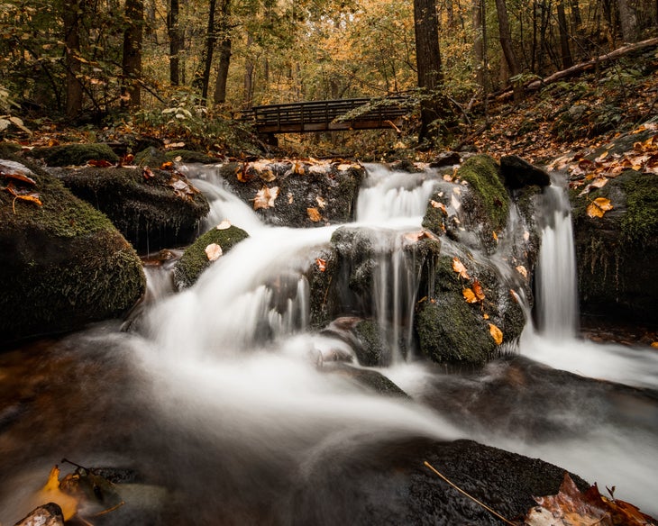
When the snow starts melting and the spring rains hit, you know what that means: It’s waterfall season. Whether dropping through deep forest or off a seaside cliff, standing close enough to one of these cascades to feel their spray is an eye-opening experience. And the best waterfalls—the ones you remember long after the season’s changed—are the ones that take a little more commitment to reach than just driving to an overlook. Here, we’ve collected six of the best places to get your hike-in waterfall fix this year. Updated May 2023
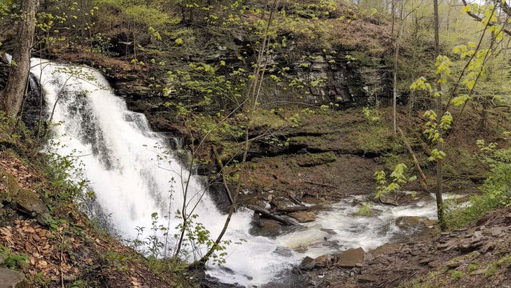
Falls Trail, Ricketts Glen State Park, PA
- Distance: 3.5 miles
- Time: 2.5 hours
- Elevation gain: 970 feet
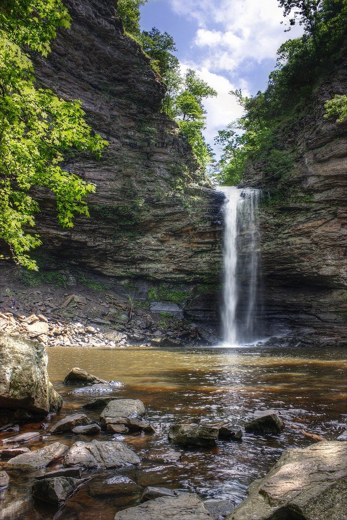
Want to pack as many waterfalls per mile as possible into your trip? You could do worse than Ricketts Glen. Tucked into the densely-forested mountains of northeastern Pennsylvania, this popular state park features 21 named falls, ranging from short drops to 94-foot Ganoga Falls. That’s the prize that’s lured us out of our campsite on this rainy, chilly May morning. Carefully, we pick our way down the wet steps, trekking poles sinking into the mud between stepping stones, until we’re as close as the trail will let us get to the base of the cascade. Above us, the placid stream we crossed on a wooden bridge earlier in the hike turns into a torrent, loud enough that I need to raise my voice to make myself heard. Even here, more than two dozen feet away, I can feel the spray of the waterfall misting my already-wet face.
Normally, you can see all of of the park’s waterfalls on a single 7.2-mile lollipop loop, but because of a rock ledge collapse, a crucial section of trail is closed, turning this trip into an out-and-back. Once we’ve had our fill of the falls, we’ll need to retrace our path back up the same rugged stone steps we descended. Right now, with the roar of the falls ringing in my ears, I can’t help but think it’s worth it. —Adam Roy
The Trail
You can see 14 of the park’s waterfalls on a rugged, 3.5-mile horseshoe-shaped out-and-back on the Falls Trail . Starting at the Lake Rose Trailhead, head south and east on a wide, well-maintained footpath through the woods, continuing past the intersection with the Highland Trail shortly after you start and following the trail as it bears left past Old Beaver Dam Road Trail at about .3 mile in. As you pass the first of the waterfalls, 37-foot Mohawk, the trail begins to descend down a set of rough stone steps (wear footwear with good grip).
At the top of Ganoga, the trail steepens, switchbacking to the falls’ base, then follows the creek as it passes a series of smaller falls, including the curtain-like 37-footer Delaware. At 1.25 miles in, the trail reaches Waters Meet, where it intersects with Kitchen Creek; turn left and follow the trail uphill toward the Glen Leigh side of the park to the trail closure at Ozone Falls. Retrace your steps to the trailhead, or turn left at Waters Meet and follow the trail downstream to PA 118 before heading back to add another 3 waterfalls and 3 miles to your hike.
Camping
There’s no backpacking in 13,193-acre Ricketts Glen. Instead, grab a lakeside tent site in the park’s Big Loop (sites 33-40 are prime real estate) and use it as a basecamp to explore the area’s 26 total miles of trail.
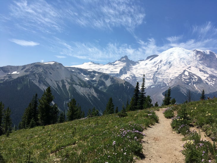
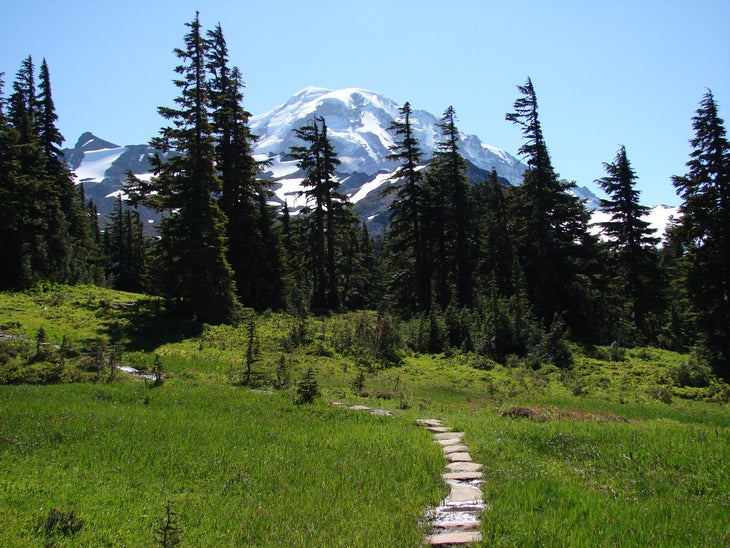
Spray Park Loop, Mt. Rainier National Park, WA
- Distance: 15.6 miles
- Time: 3 days
- Elevation gain: 6,303 feet
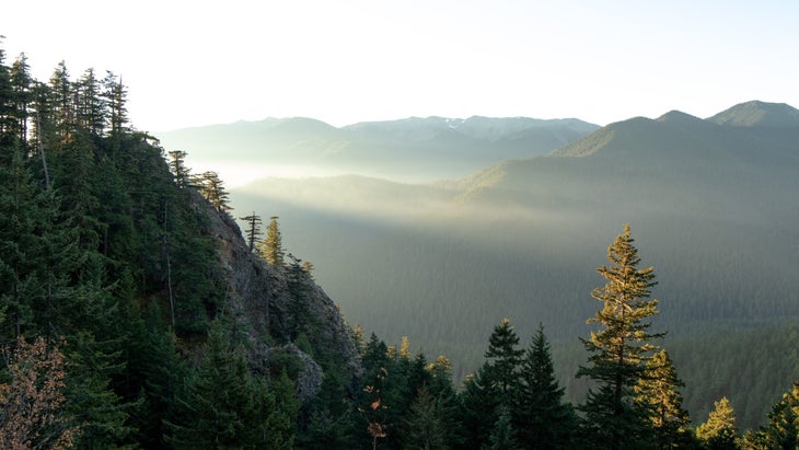
Call it the face that launched a thousand trips: The view of Mt. Rainier’s northwestern façade from Spray Park, where overflowing lupine and paintbrush blooms jostle each other to get into the frame, may just make for the most memorable photo op in the park. There’s just one problem today: I can’t actually see the peak. On this summer morning, chilled mist swirls among the wildflowers, blotting out the postcard view. But I don’t mind: The fog lends an otherworldly vibe to the scene and keeps fair-weather hikers away, giving me a rare chance to savor the colorful meadow in solitude. Besides, as I’ll be reminded over and over again on this 16-mile loop through high-altitude scree fields and lush temperate rainforest, you don’t have to see the mountain to feel its power.
Despite the long gravel road that must be ascended to reach the trailhead, Spray Park is one of Mt. Rainier National Park‘s most popular trails. And no wonder: On a clear day (or even a cloudy one), this meadow brimming with wildflowers beneath the icy peak of Rainier is hard to beat. Many visitors do it as a day hike, lingering at the Park for lunch before heading back to their cars. To truly experience this wild corner of the Pacific Northwest, though, a weekend backpack is the way to go. On a clear night you can watch the Milky Way wheel over the snowy Tatoosh Range; on a cloudy day (Mt. Rainier averages just under 200 days of rain per year), the drumming raindrops send you peacefully off to sleep. —Elisabeth Kwak-Hefferan
The Trail
From Mowich Lake Campground, take the Wonderland Trail .2 mile. Pick up the Spray Park Trail and take it 5.4 miles through subalpine meadows (Don’t miss the view of 350-foot Spray Falls near mile 2) to Cataract Valley Camp, where you’ll pitch camp for your first night out. Continue north to a fork at mile 7.7. Follow the rerouted Wonderland Trail (a 2006 flood washed out the original) to Ipsut Creek Camp at mile 11.4. The next morning, head 5.1 miles over 5,100-foot Ipsut Pass to the trailhead.
Campsite 1: Cataract Valley Camp (mile 5.6)
Bed down in an electric-green understory at this seven-site camp. Despite its name, you won’t get waterfall views, but nearby salmonberries fruit in July and a stream makes water duty easy.
Campsite 2: Ipsut Creek Camp (mile 11.4)
This site on the ice-blue Carbon River was a car campground before a monster storm washed out the 5-mile access road. Without traffic, it’s now a mellower destination for backpackers looking to linger another night on this loop.
Berries
Prepare for stained fingertips: Tempting thickets of the Northwest’s tastiest berries line this route. Harvest salmonberries and blueberries near Cataract Valley Camp; huckleberries on the climb to Ipsut Pass; and thimbleberries and raspberries near the Carbon River. Park guidelines limit you to what you can snarf on the spot.
Ozark Highlands Trail, Richland Creek Wilderness, AR
- Distance: 22 miles
- Time: 1-2 days
- Elevation gain: 1,566 feet
“One of the most scenic areas in this country. And I do mean the United States.” That kind of praise usually is heaped upon famous national parks and skyscraping mountain ranges. But this glowing description, from trail guru Tim Ernst, refers to Arkansas’s little-known Richland Creek Wilderness, an 11,800-acre parcel of turquoise pools, terraced bluffs, and waterfalls nestled within the Ozark National Forest. Richland Creek’s lack of notoriety has kept it off the radar of most hikers. The swath of spellbinding wilderness is as wild as ever, with few maintained trails or signs.
The creekside path I’m on writhes, drops, climbs, and sometimes disappears entirely while serving up tantalizing glimpses of inviting water and soaring bluffs. The turquoise-green Richland Creek tumbles through boulder chutes and over minifalls flanked by 60-foot limestone cliffs. As I follow it, I have to shuffle across craggy rock outcrops and crawl under fallen trees. Reaching a confluence, I splash across the shallow water and clamber uphill a half mile to a pair of terraced falls. The two are opposites: The left branch gushes water like a hydrant, while the right floats down in a delicate, lacy sheet. —Marty Tessmer
The Trail
Start at the Richland Falls Campground. At the east end of the bridge, take the trail entrance and head north along Richland Creek. This is a section of the Ozark Highlands Trail, so it is usually well-maintained, but some sections may still be more bushwhack than hike—come prepared with brush-ready clothes and sturdy boots. There aren’t any established campsites along this stretch of trail, so plan to look for a good flat spot near a water source around mile 11, near Dry Creek and entertainingly named Lawyer Hollow. Looking for a more advanced routefinding adventure? After retracing your steps to the trailhead, follow Richland Creek west along narrow-use trails to its confluence with Big Devils Fork at mile 5, where the two 20-foot cascades of Twin Falls await.
Cascading Abundance
There are more than 30 known waterfalls in the Richland Creek watershed alone, ranging from low Richland Falls (only 8 feet tall, but 100 feet wide) to 78-foot Terry Keefe Falls (You can pick up a map of all of them at the Waterfall Welcome Center). The limestone and dolomite that underpins most of the Ozarks is perfect for forming cascades in a wet region like the Richland Creek watershed, eroding into stair-steps, narrow canyons, and cliff-splitting slots beneath a constant flow of water. The secret? The chemical compositions of limestone and dolomite (CaCO3 and Ca,Mg (CO3)2 respectively) are easily broken into water-soluble ions, which means the rock dissolves readily beneath any persistent stream.
Waterfall Glen Loop, Waterfall Glen Forest Preserve, IL
- Distance: 11 miles
- Time: 1 day
- Elevation gain: 478 feet
This donut-shaped forest preserve 18 miles southwest of Chicago encircles the Argonne National Laboratory, and the absence of high-volume streets through the lab campus lends it a lightly-traveled feel. With the exception of occasional access roads and chain link fences, it feels remarkably remote, with almost no hint that you’re circling one of the country’s largest government-funded research facilities.
This route takes a clockwise approach to the preserve’s main loop trail—an 8-foot wide limestone-covered beauty—and crosses three roads during the first mile. The trail meanders past the cattail-fringed 91st Street Marsh and cruises dense stands of oak and pine before a short, out-and-back detour to a picturesque waterfall on Sawmill Creek. The main trail skirts the top of the creek’s ravine and heads west through a series of relic foundations before another short detour at mile 5.3. The short climb to the bluff-top overlooking the Des Plaines river valley is worth the huffing and puffing. Enjoy a sprinkling of ponds, marshes, and more pine plantations before heading north, then head east to end the loop. Just before returning to the parking area, a footbridge crosses a lovely section of Sawmill Creek.

The Trail
After grabbing a map from the trailhead kiosk on the park’s north side, follow the trail near the water fountain and restrooms. Turn left at the first junction after the parking lot. You’ll immediately cross Northgate Road and in another 250 yards you’ll cross Cass Avenue. Use caution on these street-level crossings. The trail climbs as it jogs north then south. You’ll pass Mile Marker 9 before crossing 91st Street. A trailside bench sits alongside the wooded banks of the 91st Street Marsh, which is more a small lake than a wetland. Stop to watch stands of swaying cattails and swallows twirling over the surface of the water.
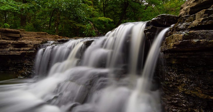
Trees, mostly red, jack, and white pine planted for erosion control in the 1950s, take center stage on the next stretch of trail, where gnarled limbs of stately oaks reach shade the path. Near mile 2.6, cross Bluff Road. The trail skirts another trailhead parking area; continue on the main trail that winds around the parking cul-de-sac. Turn right at the next road crossing to include a 0.5-mile out-and-back on the Rocky Glen trail. The trail ends at a 5-foot limestone waterfall built by the Civilian Conservation Corps in the 1930s.
Backtrack to the intersection, then continue on the main loop trail. You’ll approach Sawmill Creek again as the trail turns south; The creek flows through an 80-foot-deep ravine on the right side of the trail. Look for black and white oak, as well as bitternut and shagbark hickories, growing on the steep sides of the bluff. At the T-junction, jog left then right to stay on the wide, limestone-covered trail. You’ll dip toward the trail’s lowest point and cross the creek near some train tracks up ahead. After the electrical switching station, you’ll pass through an area that served as a plant nursery for Chicago parks: Look for several concrete-and-stone building foundations from the early 1910s, when the nursery was in operation.
Stay straight on the service road where the trail makes a sharp right. You’ll make a short climb to an overlook offering an expansive view of the Des Plaines River valley and the small town of Lemont to the south. After enjoying the view from the trailside bench, backtrack about 150 feet and turn north on the trail. At mile 6.9, pass the trailhead and stay straight on the main loop trail to continue toward the end of the loop. Turn right at Westgate Road to parallel it for about 500 feet before crossing to the trail on its north side, then turn left at the junction with the Tear-Thumb Trail, bypassing it in favor of the more forested main loop. After scouting for great blue herons near the Tear-Thumb Marsh, a small footbridge leads over Sawmill Creek. The parking lot is straight ahead. —Mapped by Ted Villare
The Name’s Waterfall—Seymour Waterfall.
Oddly, this picturesque waterfall didn’t inspire the name for the forest preserve. It is actually named for a man named Seymour Waterfall, an early forest preserve district commissioner. The first 75 acres of the park were the district board’s first purchase back in 1925; today the preserve covers 2,503 acres of ecologically important Illinois woodlands, wetlands, and prairie.
Enchanted Valley, Olympic National Park, WA
- Distance: 27.2 miles
- Time: 2-4 days
- Elevation gain: 4,641 feet
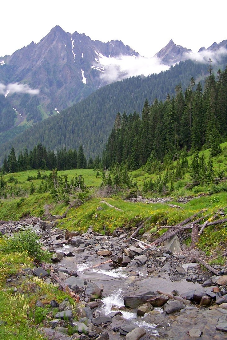
In spring, Olympic National Park divides into two different worlds: the lower river valleys, which become a hiker heaven inundated by snowmelt, and the high country, still buried under feet of the white stuff. Tap into the best of both by hiking through the rainforest along the East Fork of the Quinault River while a massive network of ephemeral streams cascades down sheer rock walls beneath 6,911-foot Chimney Peak, creating an amphitheater of falls.
The endpoint of this trek, Enchanted Valley, is aptly named. Black bears, Roosevelt elk, and harlequin ducks are regular visitors; the backcountry campsites there have front-row seats to several waterfalls dropping hundreds of feet down a cliff-fronted ridge of dark grey rock. The Enchanted Valley Chalet, currently closed due to erosion by the river, is on the National Historic Register of Places and completes a scene that has changed little since it served as an Aircraft Warning Station during World War 2. Though the skies are often cloudy, the rushing Quinault River and moss-hung trees stand out even in the mist, and the roar of the cascades across the valley rings out even through clouds. On a sunny day, the mountain views are hard to beat. Head into the rainforest for a weekend or more and spend it exploring all this valley has to offer. —Charlie Wood
The Trail
Start at Graves Creek Campground. At the first junction, go left, continuing on the abandoned road that serves as this section of trail. At mile 2 the road turns to singletrack, descending steeply through thick forest to a picturesque bridge over the East Fork Quinalt. From there, the trail parallels the river, winding through a mixed forest of alders, maples, and enormous firs. At mile 6.7, cross O’Neil Creek to O’Neil Creek Camp, a good stopping point for an easy first day if you extend this trip beyond a weekend. The next campsites are at Pyrite Creek at mile 9.5, which has twelve established sites. Camp in established sites with bear wire at the Enchanted Valley backcountry camping area. The best sites, though, are at Enchanted Valley, 13.5 miles from the trailhead; Bears frequent this area too, so store your food well. You can reserve your sites and wilderness permit online up to six months in advance.
A Unique Ecosystem
Temperate rainforest is found in only a few spots around the world: Chile, New Zealand, Southern Australia, and the northwest United States. The rainforests of Olympic National Park once lined the coast from southern Oregon to Alaska, but logging, urban development, and other human activities have destroyed all but a few isolated areas. Olympic National Park protects one such remnant, where old-growth trees persist and hikers can experience this fascinating ecosystem. Twelve to fourteen feet of rain per year and temperatures that rarely deviate from between 32 and 80 degrees Fahrenheit set the stage for an explosion of plant growth. One important component of this forest is epiphytes, plants that grow around or on trees. In Olympic, these include mosses, ferns, and lichens. The oldest trees in Olympic’s river valleys, often hung with epiphytes far into the canopy, can live for hundreds of years and reach heights of 250 feet and circumferences of 60 feet.
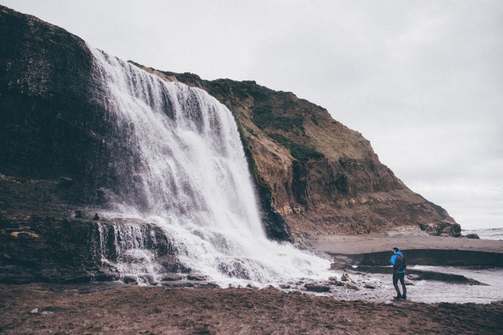
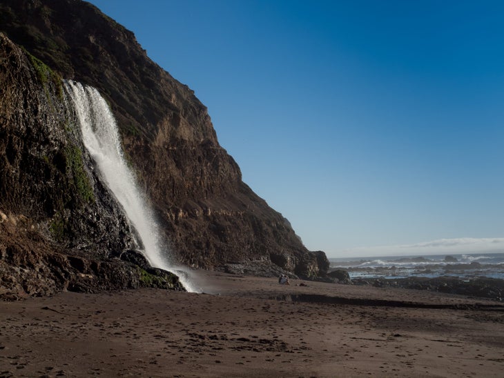
Alamere Falls, Point Reyes National Seashore, CA
- Distance: 13.1 miles
- Time: 2 days
- Elevation gain: 1,548 feet
It’s the classic question: Would you rather use your vacation to go backpacking or spend it on the beach? The beautiful thing about Alamere Falls is that you don’t need to choose. To get to this cascade in Point Reyes National Seashore, you’ll hike through coastal forest and scrubland, soak in clifftop views of the ocean, then trek a final mile and change down the beach to where 40-foot Alamere Falls spills dramatically from a seaside cliff onto the sand.
There’s no single path that leads to Alamere, giving hikers their choice of routes; it’s even possible to cycle everything but the last 1.1 miles to the cascade. To make it there successfully you’ll need good timing, though: During high tide and periods of heavy surf, the ocean covers the beach, making the route to the waterfall impassable. Check tide tables and the forecast before heading out, and be prepared to turn back if conditions are bad. —Adam Roy
The Trail
Our route of choice to get to the falls is this 13.8-mile round trip which follows the aptly-named Coast Trail to Wildcat Campground, the jumping-off point for the beach walk. Starting at the Palomarin Trailhead, follow the Coast Trail along the edge of a sea cliff with views out over the Pacific, then head inland after about a mile before dropping into and then climbing out of a valley. Starting at mile 2.8, you’ll pass a series of small lakes, starting at Bass Lake (a great place to take a dip on hot days—follow the dirt trail to the lakeside and keep an eye out for the rope swing) and then passing Pelican Lake, a blue pond fringed with verdant hills. At mile 4.2, stay right at the junction with the Ocean Lake Loop Trail and follow the Coast Trail as it wanders through coyote bush, blackberry, and yellow bush lupine scrublands, skirts Wildcat Lake, and drops down into the campground. From there, a 1.1-mile ramble down the beach takes you to the base of Alamere, where you can soak in views of the cascade on one side and the seemingly endless Pacific on the other.
More Tidefalls
As a tidefall—a waterfall that flows directly into the ocean—Alamere falls is in rare company. But it’s not the only torrent of its kind: Head a few hours south to Julia Burns State Park and you can visit McWay Falls, where the creek of the same name tumbles 80 feet into the waters of Big Sur at high tide. Unlike Alamere, visitors aren’t allowed on the beach at the base of the falls; instead, view the cascade from the overlook, which lies at the end of a quarter-mile graded trail. Prefer getting up-close and personal? Third Beach Falls in Washington drops seasonally into the Pacific Ocean in Olympic National Park. To get there, follow the trail 1.3 miles from the Third Beach Trailhead to the seaside; if the 119-foot falls are running, you’ll find them about a half-mile south.
Tips for Waterfall Hiking
Want to go chasing waterfalls? Here are a few things to keep in mind.
Quick-dry clothes are key. Even if you’re not approaching the cascade, you’ll likely end up spritzed.
Use caution before swimming under waterfalls. Even where allowed, cold water, heavy flow, and underwater hazards can make taking a dip dangerous.
Keep in mind that waterfalls’ flow varies by season. While some run consistently through the year, flow usually peaks in late spring and early summer, and some dry up entirely by fall. If in doubt, ask around, look at flow rates for the stream that feeds it, or check recent trip reports.
From 2023