Historic Monuments Zone of Querétaro (Mexico)
UNESCO Urban Heritage Atlas: Cultural mapping of historic cities and settlements
"The old colonial town of Querétaro is unusual in having retained the geometric street plan of the Spanish conquerors side by side with the twisting alleys of the Indian quarters. The Otomi, the Tarasco, the Chichimeca and the Spanish lived together peacefully in the town, which is notable for the many ornate civil and religious Baroque monuments from its golden age in the 17th and 18th centuries."
Historic building attributes
The city of Querétaro features many outstanding buildings, notably from the 17th and 18th centuries. Within the World Heritage property, there are 1,400 listed buildings, the vast majority being residential buildings. Twenty buildings have religious uses, and fifteen are used for public services.
Religious buildings
As Querétaro was not intended to be an episcopal seat, no cathedral was planned. Instead, the city was settled by religious orders who built outstanding architectural ensembles such as the convents of Santa Clara, Santa Rosa, Santa Teresa and El Carmen.
Civil architecture
Querétaro’s historical civil buildings are most valued as an architectural ensemble. This is because they correspond with the Baroque period and follow a strict typology of courtyard buildings with arcades on three sides.
Traditional architecture, especially low-rise courtyard houses, is characterised by its colourful facades and rectangular shapes with flat roofs closed to the street.
Baroque architecture
The architecture of Querétaro is a unique cultural expression of the local and historical context, both in its architectural and decorative expressions. Especially, the wide range of multilobate arches found only in the interiors of the houses and palaces give the Baroque architecture of Querétaro an "exceptional and original character" (SOUV), enhanced by the pink stone that is typically used.
Attributes of urban elements
"The different urban elements (...) include its design, its plazas, open spaces such as Alameda, neighbourhoods, the aqueduct, monuments and fountains, and civil and religious construction, that form a harmonious whole. "
The town of Santiago de Querétaro was founded in 1531. The historic centre extends into an area of 4 km2 and 203 blocks. The layout of the historic centre symbolises its multi-ethnic population and is a testament to the town's Otomi, Tarasco, Chichimeca and Spanish coexistence. At the time, the original indigenous trapezoidal layout was maintained. The urban plan was initially divided into two sections by a central axis: "one rectilinear and intended for Spanish settlers, and the other organised around smaller, winding streets where the indigenous population lived" (WHC-13/37.COM/8E, p. 190). These indigenous and Spanish traces are reflected in the urban atmosphere and the population.
© Coordinación de Ciudades Patrimonio CCPH / Municipio de Querétaro
© Coordinación de Ciudades Patrimonio CCPH / Municipio de Querétaro
In our days, the streets in the historic centre of Querétaro are characterised by low-rise courtyard houses, amongst which monumental religious complexes emerge. Their bell towers define the skyline of the historic centre. Another characteristic type of street in Querétaro is the andadores or walkways. These pedestrian streets represent important spaces for social life, joining the different monuments, points of interest and squares.
© Coordinación de Ciudades Patrimonio CCPH / Municipio de Querétaro
Public spaces
The public spaces of Querétaro, such as its plazas, open spaces, the aqueduct, monuments and fountains, form a harmonious whole with remarkable consistency, unity and urban integrity. In addition, gardens are an essential element in the historic centre of Querétaro, as places of social life, preserving urban nature and providing share and freshness in a hot climate.
© Roberto Galan / Shutterstock.com*
Plaza de Armas
The Plaza de Armas is the city's oldest square and government seat. Its space is occupied by gardens in the centre, surrounded by government buildings with arcades on two sides. The buildings, now utilised as headquarters for political events and traditional festivals, were previously residences of leading citizens. One of these, the Casa de la Corregidora, is the Headquarters of the Executive Power of the State, where the independence of Mexico began. Nowadays, the square is mainly pedestrian, with only one of the streets that flank the square allowing the passage of cars.
© Instituto Municipal de Planeación del Municipio de Querétaro
Alameda Hidalgo
This large urban park was created at the end of the 18th century by the first Corregidor of Letters, Mr Ignacio Ruiz Calado, as a place of recreation that reflected the social needs of the period. The park's main entrance faces Avenida Zaragoza, one of the city's main traffic arteries. The Alameda, with more than 6,000 trees, became a meeting place for families to promenade during Sundays. This custom has been maintained through the years. In our days, the Alameda is also a popular spot for exercising.
© M & G Therin-Weise *
Jardín Zenea
This lush garden faces the church of San Francisco in the city centre. This 19th-century garden includes a kiosk and fountain of the same period. Also known as Jardín Obregón, it was part of the atrium of a Franciscan convent. Later, a bullfighting ring was built in the area. The lot was later abandoned and transformed in 1867, adding a market, a garden and the Grand Hotel. In 1990, the place was remodelled, restoring the original layout and name.
Infrastructure
Aqueduct
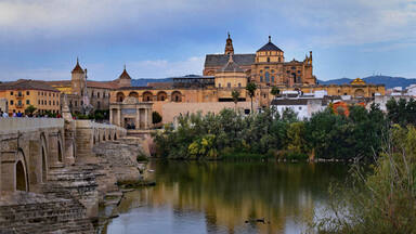
The aqueduct is the most representative infrastructure work of the city. This construction was built in the 18th century to bring water from the springs of the Ojos de Agua del Capulín in the Cañada to the fountains of the city. With 74 arches, 72 pillars and heights ranging between 27 - 36 metres, this arcade is more than 1,270 metres long.
Interactive mapping
Use the interactive mapping tool to explore the different layers that compose Querétaro's urban heritage. Browse through the tabs to navigate through the different scales of the city and the attributes of its urban heritage identity. Expand the legend on the bottom right corner to discover more. Click on the areas and icons to open pop-ups and learn more about the different areas and buildings.
Attributes of the wider setting of the city or settlement
The World Heritage property “Historic Monuments Zone of Querétaro” is located in the city of Santiago de Querétaro, in the state of Querétaro in Mexico. Located in North-Central Mexico, Santiago de Querétaro, also referred to as Querétaro, is a cultural city home to 878,931 inhabitants and a metropolitan area of over 1.5 million.
Located on a flat valley defined by two chains of hills, the urban area stayed within the confines of the historic centre until the second half of the 20th century, when the city underwent a period of expansion.
Intangible heritage values
The urban planning of the city has a symbolic meaning, representing its multi-ethnic population and the historical coexistance of the Otomi, the Tarasco, the Chichimeca and the Spanish (SOUV). Its continuous existance as a living urban ensemble contributes to its authenticity.
References
- ICOMOS. (1996). Advisory Body Evaluation. https://whc.unesco.org/document/154288
- Instituto Municipal de Planeación. (n.d.). Management and conservation plan of the Historic Monuments' Zone of Querétaro. implanqueretaro.gob.mx/im/st/4/wid_mc/PMCZMHSQEng.pdf
- World Heritage Committee, 20th Session. (1996). Decision CONF 201 VIII.C. https://whc.unesco.org/en/decisions/3001
- World Heritage Committee, 37th Session. (2013). Document WHC-13/37.COM/8E. https://whc.unesco.org/archive/2013/whc13-37com-8E-en.pdf
- World Heritage Committee, 37th Session. (2013). Decision 37COM 8E. https://whc.unesco.org/en/decisions/4964
- World Heritage Nomination Dossier 792. (1996). UNESCO Archives.
Links
- Historic Monuments Zone of Querétaro, inscribed on the UNESCO World Heritage List (1996).
- Franciscan Missions in the Sierra Gorda of Querétaro, inscribed on the UNESCO World Heritage List (2003).
- Queretaro, UNESCO Creative City of Design (2019).
- Mariachi, string music, song and trumpet, inscribed on the Representative List of Intangible Cultural Heritage of Humanity (2011).
- Traditional Mexican cuisine - ancestral, ongoing community culture, the Michoacán paradigm, inscribed on the Representative List of Intangible Cultural Heritage of Humanity (2010).
- Places of memory and living traditions of the Otomí-Chichimecas people of Tolimán: the Peña de Bernal, guardian of a sacred territory, inscribed on the Representative List of Intangible Cultural Heritage of Humanity (2009).
- Indigenous festivity dedicated to the dead, inscribed on the Representative List of Intangible Cultural Heritage of Humanity (2008).
© UNESCO, 2023.
Project team: Jyoti Hosagrahar, Mirna Ashraf Ali, Alba Zamarbide, Carlota Marijuán Rodríguez, Giacomo Martinis, Marta Zerbini.
* Illustrations marked with an asterisk have all rights reserved. Permission is required for their reuse.


 Mexico
Decisions / Resolutions (2)
The World Heritage Committee,
1. Having examined Document WHC-11/35.COM/8E,
2. Adopts the retrospective Statements of Outstanding Universal Value, as presented in the Annex I of Document WHC-11/35.COM/8E, for the following World Heritage properties:
- Afghanistan: Minaret and Archaeological Remains of Jam; Cultural Landscape and Archaeological Remains of the Bamiyan Valley;
- Bahrain: Qal'at al-Bahrain - Ancient Harbour and Capital of Dilmun;
- Benin: Royal Palaces of Abomey;
- Botswana: Tsodilo;
- Cameroon: Dja Faunal Reserve;
- Central African Republic: Manovo-Gounda St Floris National Park;
- China: Three Parallel Rivers of Yunnan Protected Areas;
- Germany: Upper Middle Rhine Valley;
- India: Manas Wildlife Sanctuary;
- Kenya: Lake Turkana National Parks; Lamu Old Town;
- Malawi: Chongoni Rock-Art Area;
- Mali: Old Towns of Djenné;
- Pakistan: Fort and Shalamar Gardens in Lahore;
- Peru: Chan Chan Archaeological Zone;
- Philippines: Rice Terraces of the Philippine Cordilleras;
- Senegal: Island of Saint-Louis;
- South Africa: iSimangaliso Wetland Park; Robben Island; Mapungubwe Cultural Landscape; Cape Floral Region Protected Areas; Vredefort Dome;
- Togo: Koutammakou, the Land of the Batammariba;
- Turkey: Historic Areas of Istanbul;
- Uganda: Bwindi Impenetrable National Park; Rwenzori Mountains National Park;
- United Republic of Tanzania: Ruins of Kilwa Kisiwani and Ruins of Songo Mnara;
- Yemen: Old Walled City of Shibam; Old City of Sana'a;
- Zimbabwe: Mana Pools National Park, Sapi and Chewore Safari Areas;
3. Decides that retrospective Statements of Outstanding Universal Value for World Heritage properties in Danger will be reviewed in priority;
4. Further decides that, considering the high number of retrospective Statements of Outstanding Universal Value to be examined, the order in which they will be reviewed will follow the Second Cycle of Periodic Reporting, namely:
- World Heritage properties in the Arab States;
- World Heritage properties in Africa;
- World Heritage properties in Asia and the Pacific;
- World Heritage properties in Latin America and the Caribbean;
- World Heritage properties in Europe and North America.
Wet Tropics of Queensland
486
Australia
N(i)(ii)(iii)(iv)
In accordance with the wishes of the Bureau at its last meeting in June 1988, the Committee noted that the Bureau had re-examined this nomination taking into account the revised evaluation of IUCN and additional information provided by Australia, as requested by the Bureau. Following this re-examination, the Committee decided to inscribe this property on the World Heritage List. It recommended that an appropriate management regime be established. The Committee furthermore recommended that IUCN continue to monitor the status of conservation of this property and report back to the Committee in the next 2 to 3 years.
Read more about the decision